Corinth Canal, Greece
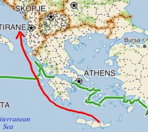
The green path shows our 2015 journey east across Greece, using the Corinth Canal. The red path shows roughly how we will sail NW across Greece in 2016 once we leave Crete and make our way north up the Adriatic.
This year, when we reverse course and sail back through the Mediterranean from east to west, we have to decide at what latitude we will pass through Greece. We pick up Aria in Crete, so we have a choice – do we sail north through the Cyclades and then cut across Greece via the inland waterways (going back the way we came last year), or do we sail around the southern side of the Peloponnese? Winds will favor sailing northwest rather than straight north, and we prefer to experience new destinations, so we will follow the red line to the right, and check out the southern coast of the Peloponnese.
In case others are considering the two options, it’s good to know what it’s like to take the passage through central Greece, using the historic and scenic Corinth Canal. This was the course we chose last summer.
After sailing through the Ionian Islands on the west side of Greece, we stopped to haul out and have boat work done in Preveza. From there, we wanted to get to Mykonos in time for a friend’s birthday so it made sense to get to the Aegean as directly as possible by crossing the Gulf of Patras, then the Gulf of Corinth, and finally the Corinth Canal. Using the canal isn’t inexpensive (about 350 euros), but it’s a great time-saver.
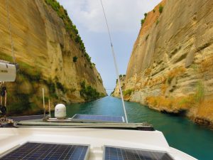
Golden Glow in the Corinth Canal
Until the late 1800’s, the Peloponnese was technically a peninsula, connected to mainland Greece by the thin sliver of the Isthmus of Corinth and surrounded by water on three sides. This required voyagers to either sail all the way around the Peloponnese, adding 430 miles to their journey, or portage their boats over land to get from the Aegean to the Adriatic.
For as long as there have been boats on the Mediterranean, yoyagers wanted a shortcut to going all the way around the Peloponnese. The first to attempt to dig a canal to open the passage to the Aegean was was Periander, the tyrant of Corinth in the 7th century BC. Such an ambitious undertaking was beyond the technical capabilities of ancient times, but Periander was able to achieve another engineering accomplishment: the diolkós or a stone road, on which the ships portaged the last few miles on wheeled platforms from one sea to the other. By the time Tiberius was in power, the portage system was improved with a device that used logs to roll boats along the isthmus, in a way similar to how the Egyptians rolled blocks of granite to build the pyramids.
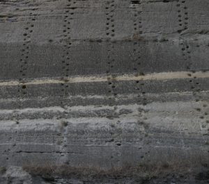
these holes on the sides of the canal were used as footholds by construction workers who built the canal
Dimitrios Poliorkitis, King of Macedonia in the 4th century BC, was the next to try to build a canal. However, his engineers mistakenly thought that the Adriatic sea was higher than the Aegean and warned him against building a canal by telling him that if the seas were connected, the Adriatic would flood the Aegean. At the time, it was also thought that Poseidon, god of the sea, opposed joining the Aegean and the Adriatic seas. The same fear also stopped Julius Caesar, Hadrian and Caligula.
In the 1st century of the common era, the Roman emperor Nero again tried to build a canal, ordering 6,000 Jewish slaves to dig using spades. He started the work himself, digging with a golden hoe, while music was played. However, he was killed before the work could be completed and the canal effort was abandoned. It wasn’t until 1893 that the canal finally was completed after 11 years of using more modern construction methods.
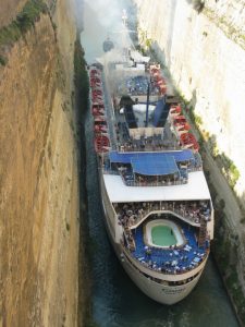
it can be a tight squeeze for commercial boats using the canal
The canal is four miles in length, 8 meters deep, and only 70 feet wide at the waterline, thus it is too narrow for most modern ships. You might wonder how traffic through the canal works — you wouldn’t want to get to the middle and face a boat coming the other way! The canal-masters allow boats from each direction only at certain times of day. You must call the “Isthmia Pilot” on VHS channel 11 asking for permission to enter, and they tell you when to line up and when to begin your passage. We spent the night anchored in Corinth near the entrance to the canal, called the pilot early in the morning and were lucky that we got in the morning lineup with very little wait time.
The canal is open 24 hours a day, except on Tuesday when it is closed for weekly repairs. 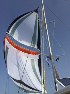 The canals high walls are limestone and the region is an active seismic zone. The wake of boats passing through the canal causes landslides, as do the vibrations from the railway and motorcar bridges over the canal. Retaining walls have been built along the water’s edge for more than half of the length of the canal to stabilize the walls.
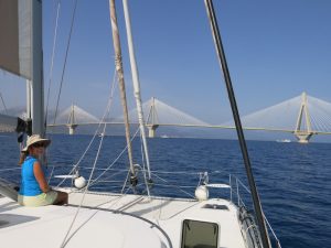
Golden Glow approaching the Rio-Antirrio Bridge
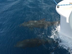
Dolphins escorted us toward the Corinth Canal
Approaching the Corinth Canal was scenic also. One of the picturesque highlights of the inland waterway passage was the Rio-Antirrio Bridge just east of Patras. It is one of the world’s longest multi-span cable-stayed bridges, and the longest of the fully suspended type. We enjoyed brisk westerly breezes, so led by dolphins, we hoisted our parasail and had a glorious sail under the bridge and through the passage between the Peloponnese and mainland Greece.
A good history of the canal: http://www.aedik.gr/frontend/index.php?chlang=EN

![corinth-canal-3[2]](https://www.svgoldenglow.com/wp-content/uploads/2016/05/corinth-canal-32-1-620x264.jpg)


Leave a comment